At Blue Sky Network, Iridium Satellite Tracking Enables Advanced Fleet Management
An Interview with CEO, Tucker Morrison | Originally published by Satellite Mobility World (SMW)
With the advent of the new Iridium NEXT constellation, the advanced satellites take on an ever more critical role in asset tracking and management. Blue Sky Network, a value-added Iridium partner, has leveraged these unique capabilities to create a series of innovative products and services for the aero, maritime, and land markets.
While there are numerous asset tracking applications, their platform combines tracking, two-way voice, and data communication, “push to talk” capability and IoT. With it, operators of aircraft, ships, and vehicles can centrally manage their fleets, ancillary equipment, and other assets and personnel – all from a convenient graphical interface. To find out more about the capabilities of this unique company, we met with CEO Tucker Morrison.
SMW: Can you give us a bit of history regarding Blue Sky Network? How did the company get started? What was its initial mission, and how has it evolved to the present day?
Tucker Morrison (TM): Blue Sky Network was founded by Jon Gilbert, a San Diego entrepreneur, pilot, and owner of a boat tracking service.
In 2001, Gilbert and Dan Colussy, the Chairman of Iridium and a former aviation executive, agreed that Gilbert would develop an aircraft tracking product using the Iridium network and get it certified by the FAA.
Early on, Gilbert realized that the data, not the voice communications capability, would be the long-term play. So, he developed a hardware device capable of transmitting flight tracking data along with two-way communication.
One of the first applications was tracking helicopters in the Gulf of Mexico that serviced offshore oil rigs. At that time, helicopters made thousands of trips per week, ferrying people to and from the rigs. As they usually flew beneath the radar, there was no easy way to track them. That’s how installing our devices onboard the aircraft to send autonomous GPS-imbedded position reports though Iridium evolved. Users of the service could view their aircraft’s positions on a Web-based display we developed, and the product became very popular. That’s how we got started.
Today, our mission is to help organizations stay connected to their high-value assets in real-time, anywhere in the world. It includes working with our legacy aircraft customers to expand their tracking capabilities and developing tracking and IoT applications for other business segments.
For example, while aviation still represents approximately forty percent of our revenue, we have engineered a successful expansion into maritime and land-mobile markets to comprise approximately fifty percent, with engineering services rounding out the balance. We now have over four hundred fifty customers around the world.
SMW: Iridium’s new Aireon service receives ADS-B and provides positioning, speed, direction, and altitude in real-time to aircraft controllers where no land-based receivers are available. Does BSN use Aireon, and how are the two services different? Please explain.
TM: While ADS-B has been around for a while, it is limited to the real-time transmission of aircraft location, altitude, speed, and travel direction. Aireon is designed for air traffic control and extends visibility across the globe in real-time. Placing ADS-B receivers on Iridium NEXT satellites made this possible.
We also plan to integrate Aireon generated data into our SkyRouter product to complement the data we are transmitting; this leads to greater insights and refined analytics to the end user.
SMW: As you know, there are quite a few aircraft and maritime tracking applications. How is Blue Sky different?
In comparing our service to aircraft positioning competitors, it’s important to note the differences.
Unlike other aircraft and maritime tracking services, our SkyRouter application tracks multiple types of assets simultaneously. It also offers two-way voice communication and “push to talk” functionality, and it supports IoT data interchange. So, we go far beyond the provision of simple position and destination information.
SMW: What is the impact of the new NEXT constellation on your product offerings?
TM: It has increased reliability and the quality of the legacy services. The short burst data has also been improved, and “push to talk” is now available.
We are also developing products for Iridium Certus’ new “100” product that promises to offer 88/22 Kbps speeds. It’s capable of supporting data streaming at very low cost via a small form factor device.
SMW: I note that you initially focused on the aero market. Why did you choose this market, and what specific aircraft segments do you serve, i.e. commercial passenger, business jets, or leisure aviation? Can you give us some examples of product usage in its key target segments?
TM: Within the aviation market, we serve air-medical, helicopters, air taxis. From an industry perspective, we also support aerial firefighting, offshore transport, and search and rescue operations.
In the commercial passenger segment, we serve small regional carriers, operating in remote locations such as Susi Air in Indonesia, TropicAir in Belize, and Air Greenland.
A typical use case would be serving an organization that operates in regions with limited connectivity solutions. The client could track aircraft position, speed, altitude, mission status, communicate with the pilot, and schedule any unexpected maintenance that might be required. In addition, tracking of support vehicles and services and pilot messaging is supported by SkyRouter.
SMW: Can you tell us more about your diversification efforts?
TM: We plan to invest in technology, people, and gaining market share. Our diversification efforts began two years ago when we acquired Applied Satellite Engineering in Scottsdale, Arizona, a satellite equipment provider.
ASE was focused on maritime and land markets and was making Iridium terminals for those markets. The acquisition provided us with hardware development, market knowledge, and specific segment-related engineering expertise.
Our engineering team has expanded to support the development of a variety of new products to serve these markets.
We now have an indoor Satcom system, a dual-mode vehicle tracking and telematics device, the HawkEye 5500, and also introduced the first known FAA-approved Autonomous Distress Tracking device, the HawkEye ADT, in late 2019.
As an Iridium VAM for the upcoming Certus 100 platform, we are designing devices to stream data from unmanned aerial systems and land-mobile applications.
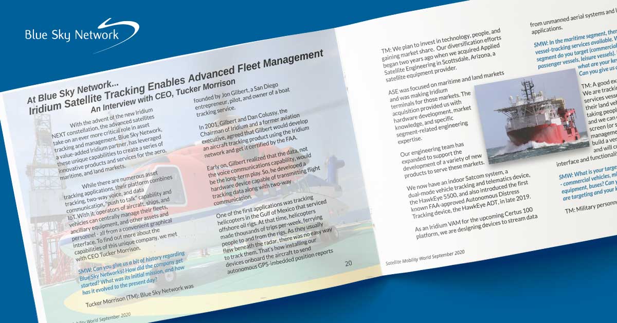
SMW: In the maritime segment, there are numerous vessel tracking services available. What specific vessel segment do you target (commercial shipping, passenger vessels, leisure vessels). In that segment, what are your key differentiators? Can you give us an actual use case?
TM: A good example is Chevron. We are tracking their platform services vessels and can also track their land vehicles and helicopters taking people back and forth to rigs, and we can do it all on a single screen (or set of screens for data management beyond tracking). We build a very comprehensive solution and will customize the user interface and functionality.
SMW: What is your target market in the land segment – commercial vehicles, military vehicles, construction equipment, buses? Can you tell us which segment you are targeting and your key differentiators?
TM: Military personnel carriers, supply vehicles, VIP transport, utility service vehicles, ambulance tracking, are a few examples.
Again, our comprehensive set of applications includes tracking of multiple assets on a single screen, voice and data communication for IoT and “push to talk”.
SMW: In the personal security segment, you compete directly against Globalstar’s SPOT Gen3, which costs only $99 and Sat-Fi 2, which provides a local Wi-Fi Hotspot w/ unlimited data for $50 per month. How do your solutions compare, and what specific personal security markets are you targeting?
TM: Unlike Globalstar, we don’t focus on the consumer leisure market. Also, recall that Globalstar coverage is limited to some geographical areas. We’re more of a B2B focused business where managing a number of assets including alerts and geofence parameters, among others, is a prerequisite.
SMW: Given the limited number of personnel in your organization and the size and diversity of your markets, how do you successfully grow it?
TM: We have an outstanding list of customers and believe we can leverage this base to provide a greater range of solutions for their fleets and data management needs.
While aviation will continue to be a large end-use application for us, the growing need for IoT applications and telematics spans multiple mobility segments.
We believe our ability to combine innovative combinations of voice and data communications, along with graphical display capability, is our greatest asset.
—
Tucker currently serves as Chief Executive Officer of Blue Sky Network, LLC. Before joining Blue Sky, he was the Chief Commercial Officer for MRO Holdings, Inc., a leading aviation services and solutions provider with three airframe maintenance and modification facilities in the U.S. and Latin America, and served as the COO and owner of its Flightstar subsidiary (prior to the parent company acquisition).